The snow came again, not so much this time, but still enough to cover the ground.
With a lot of water around and the fields soggy, we decided to go up on the edges, but which one should we choose?
We chose Gardoms edge, a short, little known, but lovely edge between
Birchen edge, and Baslow edge.
With a lot of water around and the fields soggy, we decided to go up on the edges, but which one should we choose?
We chose Gardoms edge, a short, little known, but lovely edge between
Birchen edge, and Baslow edge.
We're off to Scotland next Monday, the Isle of Arran, to be precise.
We'll be there for a week, so I'm hoping to get some really good pictures.
Anyway, back to this week. We parked in the car park next to the Robin Hood pub,
and set off over a stile and up towards Gardoms edge.
Anyway, back to this week. We parked in the car park next to the Robin Hood pub,
and set off over a stile and up towards Gardoms edge.
.JPG)
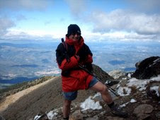
There's a small outcrop of rocks, and just for a change, it was
Sue who went up for the photocall.
.JPG) Here she is again, with Birchen edge behind her.
Here she is again, with Birchen edge behind her..JPG) Looking west, from the start of Gardoms edge. There was a very significant
Looking west, from the start of Gardoms edge. There was a very significantarchaeological find on Gardoms. You can read more about it here;
http://www.gardoms-edge.group.shef.ac.uk/Garmenu.htm
.JPG) We're right on the top of the edge now, and looking across the valley to
We're right on the top of the edge now, and looking across the valley towhere our walk is headed, Baslow edge.
.JPG) A rocky, snowy view from Gardoms edge.
A rocky, snowy view from Gardoms edge..JPG) A little snow-woman!
A little snow-woman!.jpg) And a gnome, sitting on a rock ;-)
And a gnome, sitting on a rock ;-).jpg) At the end of Gardoms edge, we dropped down to the A623 road via
At the end of Gardoms edge, we dropped down to the A623 road viathese snowy steps.
.JPG) We crossed the road, and made our way, via the old Packhorse road, up
We crossed the road, and made our way, via the old Packhorse road, upto the Wellington monument. It looks very stark in this winter setting.
.JPG)
.JPG)
A seat with a really good view, perfect for a picnic, (in better weather).
.JPG) We turned right along Baslow edge, to pass the Eagle stone,
We turned right along Baslow edge, to pass the Eagle stone, and headed for Curbar gap.
.JPG) Curbar edge, from Baslow edge.
Curbar edge, from Baslow edge.
.JPG) Curbar edge, from Baslow edge.
Curbar edge, from Baslow edge. Curbar gap is in front of us, between the two.
.JPG)
The lovely skeleton of the countryside, as mapped out by the walls.
Looking across the Baslow valley to Bramley.
.JPG) I really like these footpath signs.
I really like these footpath signs.
Thanks, Peak & Northern footpath society;
http://www.peakandnorthern.org.uk/
.JPG) We threaded our way through sometimes frozen, sometimes soggy ground,
We threaded our way through sometimes frozen, sometimes soggy ground,
below Birchen edge and back to the car. We passed this herd of
beautiful Highland cows on the way.
.JPG) A fearless Sue wanted to cuddle one, but they weren't up for it.
A fearless Sue wanted to cuddle one, but they weren't up for it.
.jpg) We were soon back at the car, and although only six miles
We were soon back at the car, and although only six miles
we felt we had stretched our legs for Arran.
.JPG)
The lovely skeleton of the countryside, as mapped out by the walls.
Looking across the Baslow valley to Bramley.
.JPG) I really like these footpath signs.
I really like these footpath signs.Thanks, Peak & Northern footpath society;
http://www.peakandnorthern.org.uk/
.JPG) We threaded our way through sometimes frozen, sometimes soggy ground,
We threaded our way through sometimes frozen, sometimes soggy ground,below Birchen edge and back to the car. We passed this herd of
beautiful Highland cows on the way.
.JPG) A fearless Sue wanted to cuddle one, but they weren't up for it.
A fearless Sue wanted to cuddle one, but they weren't up for it..jpg) We were soon back at the car, and although only six miles
We were soon back at the car, and although only six mileswe felt we had stretched our legs for Arran.
.JPG)
.JPG)
.JPG)
.JPG)
.JPG)
.JPG)
.JPG)
.JPG)
.JPG)
.JPG)
.JPG)
.JPG)
.jpg)
.JPG)
.JPG)
.JPG)
.JPG)
.JPG)
.JPG)
.JPG)
.JPG)
.JPG)
.jpg)
.JPG)
.JPG)
.JPG)
.JPG)
.JPG)