Monday 29 March 2010

Arran, part six - Holy Island


Next morning, Kath had to eject one of the 'ladies' from the house.
I hope she wasn't looking for her eggs - we'd eaten them (sorry).
We were replete from the next mega-breakfast, courtesy of Kath,
and set off for Lamlash, from where we would take the ferry to Holy Island.
Again, a lovely day, sea like a mill pond, tides right - sighhhhhhh, it's all just too good!

We even saw our FIRST seal!
There he (she??) was, looking decidedly uncomfortable, just
lying prostrate on a rock. We tried to figure out if he was just lazy,
having settled there on the last tide, and now waiting to be 're-floated'
by the next incoming one. Whatever he was doing,
we watched him for about half an hour.
Meanwhile, this guy was watching us
We reached Lamlash, only to be told that, with the lack of breeze, the tide
was coming in a lot slower than expected, and we'd have a wait of about
an hour, so we retreated to a little cafe....and waited.
As soon as it was decided there was enough water, our 'captain' took a small(er)
boat out to the good ship 'Sierra ', and we boarded and set off.
It was a chilly crossing, noticeably colder on the water than on the shore, but we soon reached Holy Island and the Buddhist monastery. You can read more about it here;

We soon warmed up in the strong sunshine, and decided to explore the lower
part of the island before starting the climb to the top.
Soon, we were pressing upwards, but no snow this time.
As we progressed, the views just got better and better.
We could see Ailsa Craig peeping at us round the corner.
You can also see the lighthouse and womens retreat (more on the latter later).
Now then - which way is it..........
(erm Sue - the top's just THERE look.......)
There's a small cairn halfway up - this is the view from there.
Lamlash is threaded out along the coastline.
If you've ever wondered where your farmed salmon comes from,
it's places like this. These are salmon pens in the bay.
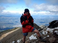
It wasn't long before we got to the top of Mullach Mor, it was only about 1.000 feet.
As you can see, the sun was getting even stronger as the day wore on.
Sue took my photo at the top...........
......and then I took hers.
It was a photographers dream come true today with these conditions.
Even the clouds 'posed'.
We spent quite a time at the top, wanting to savour every moment.
We ate a snack, then set off for the end of the island.
Again, we can see Ailsa Craig.
The path turns right before those white buildings. It is a womens retreat.
Women come here to meditate, and for some reason,
they stay for three years, three months, three weeks and two days No - only joking - it's THREE days :-)
This wooden chalet is the Llama's abode.
Beats me why he put it this end of the island, instead of the other
end where the monastary is.
(PS - that's the womens retreat again there on the left - just below the Llama's chalet...)
The path turns right, and passes beneath these huge cliffs.
Along the way, there are several rock paintings. They were done by a monk
called Dekyi Wangmo (that's easy for YOU to say!).
Holy Island is famous for these.
read more about them here;
The earliest recorded name for Holy Isle was Inis Shroin, which is old Gaelic for 'Island of the Water Spirit'. After the time when the Celtic Christian saint St. Molaise lived on the island for about 20 years at the end of the 6th century, it became known as Eilean Molaise, which is Gaelic for 'Molaise's Island'. This name gradually evolved over the course of centuries until early in the 19th century the island became generally known as Holy Isle (or the Holy Isle) and the village on the other side of the bay became known as Lamlash.
This is Sue, standing inside Saint Molaise' cave. Apparantly, he lived here for 20 YEARS.
I've no idea just WHY religion has to be so spartan and harsh.
Anyway, he had some nice views from his cave.
We sat on the shore and had a drink of coffee while waiting for the
ferry to return.
All too soon, it arrived.
Next thing, we were whizzing across the mill pond again,
this time a LOT warmer than before in the lovely sunshine.


It dawned on me that we still had plenty of daylight left, so we decided to visit
'seal shore'. This was a place at Kildonan, famous for seals and cetations.
No one knows just WHY the seals favour this area, but they come to
rest on the rocks. You can get quite close to them, if you're careful.
The next set of pictures will show you.
Apart from being yet another fabulous, quiet and serene place,
we again had it ALL to ourselves.

Sunday 28 March 2010

Arran, part five - the Stone circles

After getting all the pictures we wanted from our morning walk, we set off to the south of the island. It's flatter and more fertile here, and there is evidence of human habitation for over 8,000 years - that's some history!
Machrie Moor, in particular, seems to have been a favourite place, and there are several stone circles and standing stones still preserved there
This is one of the larger circles.
I think they were hut circles but whatever, they're very impressive!
A small standing stone, one man could have erected this.
But it would take a veritable army of men to get this one up and standing.
I can't work out if those striations at the top of this stone are
natural, or man made?
(Click on the pic for a larger version)
This single standing stone had them too.
I LOVE the background of snowy hills. We sat on a stone and had a most
agreeable lunch under the warm sun.


I was quite surprised to see what looked like a pair of millstones. The broken one had
a square cut-out in the middle, as though a shaft went in there.
After our time with the stones, we moved on to Blackwaterfoot,
on the south-west coast of Arran.
It's a sleepy little place, with a tiny harbour and a golf course.
We parked the car (free) and walked over the golf course, following the
signs to the Kings cave, which was next on our 'list'.
Another beautiful day, with the prospect of a great sunset.
This walk along the coastline was really nice and tranquil.
This holiday really was massaging the soul!
A strange rock face called 'The Doon'.
It looks a lot like the basalt pillars you see on volcanic islands.
Whatever, it was quite dramatic, and takes you by surprise after the
rolling greens of the golf course.
Looking across to Kintyre.
The 'Mull of Kintyre' is to the left of this picture.
We soon came across the entrance to 'Kings Cave'
The notice said it was sometimes locked to prevent vandalism.
Luckily for us, today it was open.
The view from inside.
It's quite a large cave, but not very deep.
I bet it could tell a tale or two of habitation over the years.
NOW what am I trying to capture?
This lovely shot. I waited AGES for those birds to take off and get into position!
I felt it was well worth the wait.
We walked back along the seashore.
All this loveliness, and we hadn't seen another soul all day.
The sun began to set, another day, another show.
I wish I could put into words how this makes Sue & I feel.
Serene......fulfilled.......relaxed....contented..... they don't even come close.
We don't lead stressful lives, but if we did (or if YOU do)..........


Tomorrow, we are going to 'do' Holy Island.
The weather is set fair - again :-)

Arran, part four - the String road & photographers heaven!

It looks like it's the rutting season! Please - no 'horny' jokes!
I don't know why I've got my fleece on - it was a fabulous, sunny morning. Kath served us duck eggs for breakfast, along with the super black pudding, sausages, bacon etc etc.
We'd seen a picture of the Goat Fell range on the wall of the B&B.
After telling Kath we admired it, she did no more than rang the photographer and asked him
where we had to go to get the same picture. He told her, and she told us.
We set off for the 'string road'. This was a road that dissected the island right across the middle. It was a high road, and had been cut off by the snow, but was now passable with care.
And here we are - parked in a drift!
This Honda has been great in all the recent snow, and gone wherever I've asked it.
We'd soon got a few hundred feet under our belts, and a look back to the string road
showed us just how well we were progressing.
The snow was getting steadily deeper though, the higher we climbed.
I think it's this way!
With no path to follow, and just our tracks in the snow, we had to pay
close attention to the map and the surrounding contours,
but it was a very clear day, so not too difficult to wayfind.
I think we should head for that ridge (crunch, crunch, crunch)...........
Luckily, we could walk on the top of the snow, but like on Goat Fell,
every now and then we sank up to our thighs.
We didn't mind though, because if that was the price to see all this beauty,
it was a small one.
A REAL winter wonderland, but with hot sunshine - phew!
I ask you - where in the world can surpass that?
The big picture was great, but we took time to look at
the snow and the tracks the animals had made.
Here, we saw a bird had run, flapped it's wings,
and taken off. Almost ghostly!
Sue walks to the perfect spot for the perfect picture!
I was just content to pose at the trig point.
In the distance behind me, you can see our destination for later in the day.
Smile please!
We're so in love with Arran that we've already booked to go again in November.
That ridge behind us to the left of Goat Fell is on the 'to do' list.
We just couldn't stop looking at this panorama.
We felt we were so lucky to be seeing it in these conditions.
I'm sure it looks great without the snow, but somehow...........
Looking at Goat Fell from here, it just doesn't seem possible that we got right to the top.
It was very hard work, but it was also VERY worth it.
Right Susie, time to go - which way?
(Just follow the footprints).
We made our way back down to the car in the strong sunshine.
The snow must be melting fast now.
We drove to the South of the island,
and the lowlands, with no snow, as you can see.

This track is what we were looking for.
Why?? Find out in the next instalment.
Clue - what we found was 6,000 years old.