Every year, two friends come over from America, and stay in Bakewell for around three weeks. They walk EVERY day, using only local transport to reach their walks. They get to see so much of the Peak District, but there are some places that are just inaccessible by bus etc, so while they were here, I took them in the car to a couple.
We went up to Kinder Scout from the Snake Pass (via Blackden Brook) on a previous walk, but today they wanted to see 'Lost Lad'. You can read up on the legend here; http://www.unexplained-mysteries.com/forum/index.php?showtopic=86891
It's been a while since I've been up there myself, so we got together with Tom, another friend, and set off to the start at the Fairholmes visitors centre on Ladybower.
The reservoir was still and reflective on this warm, Summer day.
As I stood, I heard a cuckoo, the second I'd heard this year.
I also watched pied flycatchers dancing in the sunlight and catching flies.
.JPG)
Looking down the reservoir, all looks well, but later pics will show the
water is low in the upper reservoirs.
In the drought a few years ago, I remember walking UNDER these pipes,
and the 'reservoir' was no more than a small stream running along the floor of the basin.
.JPG)
The mighty Derwent Dam, one of three in the Ladybower chain,
Howden being the third.
.JPG)
Above the dam, the rhododendrons are in full bloom now.
.JPG)
Looking down the Derwent reservoir, you can see the water is low.
.JPG)
And looking up - well, now it looks even worse.
You can see the turret of the Howden dam peeping out of the trees.
.JPG)
But soon we left the levels of the valley, and started the long climb up to 'Lost Lad' hillend.
This well-worn track is used by the grouse shooting fraternity.
.JPG)
Simplicity - just clouds and moorland - beautiful!
.JPG)
The promontory you can see is Crookstone Knoll, on Kinder Scout's north east edge.
.JPG)
The path winds across the high moors to Hillend.
.JPG)
The classic view of the Castleton skyline.
.jpg)
The final path up to Lost Lad, so popular, it has had to be paved.
.JPG)
Steven, me and Tom on the topographic cairn at Lost Lad.
.JPG)
Worn rocks on Derwent Edge
.JPG)
Some of them actually LOOK like animals.
(ok, ok - I DID add a bit to this one)
.jpg)
It wouldn't move!
.jpg)
Again, the path along the Derwent edge was well-worn and paved.
The paving stones are the floors of old mills, and are bought
by the National trust. I think they are a necessary evil, and don't look too bad.
Instead of being laid in straight lines, they are 'meandered' to be more pleasing to the eye.
.JPG)
Kinder Scout, from Derwent edge.
.JPG)
Win hill, and the 'cakes of bread'.
.jpg)
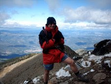
Me, with what I would say was not a bad view!
.JPG)
A MUCH better view of Crookstone knoll, now we are higher up.
.JPG)
The original plan was to do a six mile walk, but we were up here, had the luxury of time,
and it was a great day so I decided to walk us along the Derwent edge as far as the
Wheel stones, before making our descent back to the car.
.JPG)
The Ladybower viaduct was coming into view now.
.JPG)
The Wheel Stones, just beyond this, we left the edges.
.JPG)
What a SUPER view today - perfect for Steven and Steph's
last walk before returning home for another year.
.JPG)
And so we began our descent.
.JPG)
The greens of the fields, and the grey of the walls
complimented each other perfectly.
.JPG)
We reached the car in good time, now all that was left was for me to wash,
change, and get ready for an evening shift in the cafe!
Thanks to Sue for letting me run away for the day :-)